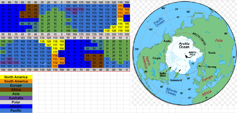
Just doing some more visualization tests between the indexed map and a polar view of earth:
These are quick approximations, so obviously my 8 bit landmasses could be adjusted and moved about a bit. 
So the most obvious difference between an actual sphere like the earth and a polar wrapped cylinder is the stretching that happens around the poles. This is pretty common when map makers translate the spherical earth onto a flat piece of paper.
This actually looks a lot better than I thought it would. It doesn’t line up perfectly around the poles, but honestly I think the big features are close enough that it should work out.
One thing I noticed in game though, is that you can just barely see any given point(say Alaska) on 2 sides of the globe when you are hovering over the pole. I feel like I am working in 4-5 dimensions and it hurts my brain…  Almost as if in the real Earth you are over Alaska, then you go to the North Pole, then you go directly South to Siberia, and then due east back to Alaska. But in game this shows up as simply North-East and halfway around the globe.
Anyway, by slightly reducing the size of the sphere projection you won’t be able to actually see this directly in game(IE see 2 of the same city on the map at the same time). If the player scrolls in a certain way and finds them self back at the city they just left much faster than intuition would allow, then this is the polar wrap/stretching at work.
Am I crazy, or should this basically work?